The Qhapaq Ñan, is the word that defines the road system of the Inca Civilization and is definitely the best material test, which can give us an idea of the magnitude of this empire, becoming one of the greatest achievements in indigenous America. An estimated 23 thousand km is calculated, although other studies say that up to 40 thousand km could be registered, from an extensive network of roads, built on one of the most rugged territories in the world, which communicates the cities and settlements of the state most important in America, before the Spanish invasion.
This network of roads crossed the Empire of the Incas, along roads drawn from north to south (from end to end) along the coast, mountains and jungle; through the Cordillera de los Andes, with small sections, which communicated from the east of its territory to the Pacific coast. Designed in harmony with the topography of the place, wide in some areas, very narrow in others, with completely cobbled sections and others simply of land.
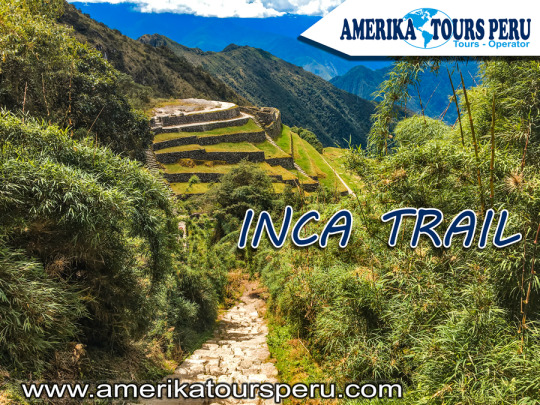
Like all the important cities of the Empire, the city of Machu Picchu, connected to Cusco (capital of the Empire), through the Inca Trail that we have traveled so far, at least two important accesses to the Sacred City (Inca Trail and Camino Salkantay), although there may be two others; one that descended through the Urubamba valley from Ollantaytambo, and another that crossed the high part of the Andes. And together with these, a complex network of secondary roads, to communicate the existing settlements throughout the region.
The world-famous Inca Trail to Machu Picchu, is only part of this complex network of roads, which goes up the Urubamba River basin to the Inca City, named for being the most suitable name. At present it is considered by many, the most beautiful of all, for the complement present between its landscapes and its history, you can visit it in three or four days, on a perfectly planned tour.
This Inca Trail to Machu Picchu, allowed to join production sites, with storage and administration centers. It is located in the middle of the jungle, which provides adequate environmental conditions for the production of specific foods. It is very likely that the entire Empire was supplied from this area. Therefore, this road articulated Machu Picchu with the capital and this with the other cities.
The gigantic network of roads of the Inca empire (Qhapaq Ñan) was built with the main purpose, to keep a huge territory communicated, this allowed to mobilize armies very quickly for the time. But it had other very important uses, as it served as trade routes, acting as an economic articulator, in a civilization with a tendency to redistribution and exchange, in the same way that Machu Picchu's corn or coca reached Huánuco, In Huánuco, surplus production (potatoes and others) was redistributed in other locations, such as Machu Picchu. Another extremely important purpose was the representation of the central power of the empire, as it was thought ideologically; -Yes, I know Cusco because I have seen the road- Then, the road was the essential ideological representation of the power of the Empire, both economic and ideological.
This path, a means of communication and transport par excellence, fundamental in economic articulation and ideological dissemination, was essential for the existence of such a vast territory. It crossed the central squares of the main towns of the Empire, joining places of worship, commerce and administration, passing through water sources, an element (fundamental for life) that symbolized the goodness of Mother Earth and the reproduction of life.
And despite the information available, the Inca Trail is only a small branch of the Empire's road network, an important tourist attraction in Peru and one of the largest in the world. Although the fact in itself, of knowing new places, what we offer is fantastic, goes beyond a visit to the Machu Picchu Sanctuary in Peru; We offer an approach to the culture of the people who built those places, to the people who currently inhabit those places, their customs and their history. So you can transform visible material evidence into an experiential learning experience.
Social Profiles


0 comentarios:
Publicar un comentario