We will pick you up from your Cusco hotel at 5.00 am in our transport, and then drive for 2 hours to Curahuasi (2909 m. / 9543 ft.), village where we will have breakfast, and then we continue to Capuliyoc, we arrive to nice view point called Capuliyoc (2915 m. / 9561 ft.), from here, we will have the privilege to see spectacular views of Padriyoc and Wayna Cachora snowcapped peaks (mountains over 5400 m.). At this point we will have some time to enjoy our snacks and we take some pictures of the breathtaking views of the river and the canyon stretching down the valley. From here we will descend through a unique zigzag path for 2 hours more to reach our place for lunch. Finally around 1 pm. we will have lunch. You have time to relax, put your feet up and have some refreshing tea, before we get ready to hike again for 2 hours more descending, so, we will reach our campsite located at Chiquisca (1836 m. / 6023 ft.) around 5 pm. where we will spend the night.
DAY 2: CHIQUISCA – MARAMPATA – CHOQUEQUIRAO RUINS
After our breakfast, we will leave early, throughout the day we will see a wide variety of bromeliads, orchids and stands of bamboo; we’ll also hope see birds such as Andean Quetzals, Toucans an a variety of hummingbirds. From our campsite we walk around 1 hour in order to descend to the bottom of the Canyon, called Playa rosalina and the magnificent Apurimac river (1550 m./ 5084 ft). From here we will begin probably the hardest section of the path due to the ascension; 2 hours steep climb to Santa rosa (2095 m. / 6873 ft.) where We will have time to take a refreshing break. From Santa rosa we will continue uphill for another 2 hours towards marampata (2913m / 9557ft), a flat ground where we can have a break and enjoy the views of Apurimac Canyon and the famous Inca site of Choquequirao. Here We’ll have lunch and take advantage of the facilities (toilets and wash room).After lunch We will continue to hike for another one hour to reach our campsite which is located just outside of the Great Inca Site Choquequirao (3110 m. / 10120 ft.) and We will spend the late evening in the ruins, where we will see a very nice sunset over mountains, and if we may be lucky enough to spot Condors soaring nearby over the valley below. Camping at Choquequirao campsite (bathrooms and cold water showers are available).
DAY 3: CHOQUEQUIRAO RUINS – CHOQUEQUIRAO PASS – MAIZAL
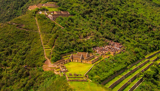
After our early breakfast we will visit the mysterious Inca site of Choquequirao, where our professional Tour Guide will explain about the history of this magnificent Inca site. Originally discovered in the 17th century by the Spanish, it lay abandoned and forgotten until recent years when tourism raised the profile of the city and exploration began. Even with this increased interest only 25% of the city has been explored and many of its secrets still wait to be discovered. Actually we can visit the most important zones such as the main plaza, the inca houses, the granaries, the ceremonial sector and its altars, the famous terraces, and the great Llama sector where Incas represented this sacred animal on their buildings. After our guiding visit, you have extra time to explore and enjoy the place by yourselves, after this, we continue with our trail, we will begin walking uphill until the highest point for this day called Choquequirao pass located at 3,300 masl. or 10,890 ft., then we will descend until to the deepest point of the small canyon known as White River or Río Blanco (1900m/6234f), On the way we will pass by Pinchiunuyoj, a small archaeological site. From Rio Blanco we will climb up for about 3 hrs. and during this time we will observe different species of birds, different varieties of orquids, and local coca plantations, we continue hiking until our campsite at the place called maizal (3000 masl. / 9900 ft.).
DAY 4: MAIZAL – SAN JUAN PASS – YANAMA
Today after a very good breakfast we will start a superb day’s hike on a path surrounded by vegetation and flowers climbing by 3 ½ hours along the way you will see evidence of mines that at one time were exploited, but are no longer used. As we continue and ascend, the weather will become a little colder and we will find the remains of an Inca trail. This trail will take us toward the pass called San Juan Pass (4200m/13,780ft). From this beautiful place you can see a great landscape with a grand chain of mountains such us Sacsarayoc, Pumasillo and Choquetecarpo, from which some of the latter peak more than 5000m/16404 feet. You will also see glaciers and many mountains that surround it. After some pictures and a break at the San Juan Pass, we’ll head down and in the distance another recently discovered Inca ruin, Corihuayrachina and the equally interesting old silver mines of Mina Victoria, and we continue Descending by 3 hours to the north into the River Yanama Valley, we follow a high trail which traverses steep slopes and provides another excellent opportunity to spot condors. We camp beside the river at the little Andean village of yanama (3530 m / 11,581 ft.). In the afternoon once again our cook will prepare a tea time for us and after a delicious dinner.
DAY 5: YANAMA – YANAMA PASS – TOTORA – COLPAPAMPA
After early breakfast, we make our way out of the Yanama valley, as we ascend we return to a more barren environment where only the local grasses and hardiest plants can survive. we will start climbing slowly to the highest point of the whole trek, this pass is known as yanama pass(4670 masl. or 15410 feet), again the view will be amazing from here, we will be surrounded by snowcapped mountains as the Sacsarayoj mountain and the Padreyoj mountain and if we are lucky we will even see a condor flying., After a small stop, from this pass we make our way down in to the valley and back in to warmer climes. About 1hour beyond the pass we arrive to a small community called totora at 3,630 masl. or 11,979 ft. where we will have our lunch. After lunch, during the afternoon, we will enjoy frequently the view of snowcapped mountains such as Salkantay (6264 m.) and Pintuyu (5450 m.) and we continue going down for another 2 hours to colpapampa (2750 m.) which is where we’ll be camping for the night; when we arrive you’ll notice a change – now that we’re nearly to Machu Picchu the communities are larger and more well supplied, there are also more tourists whom came from the route of the Salkantay trek and they converge at this point.
DAY 6: COLPAPAMPA – PLAYA SAHUAYACU
Our destination today is the village of La Playa about 12km down the valley from Colpapampa. Our route takes us along the Lluskamayo River through an area that is teeming with life and that has various coffee and fruit plantations. Tonight we will stay at the village of La Playa (2400m / 7874ft.) which is well connected and there are plenty of places where you can buy snacks and refreshments, you can also try some of the locally grown coffee. If you are interested there is the option to visit some hot springs that are close by, let your guide know in advance so that he can organise this for you.
DAY 7: LA PLAYA – HYDROELECTRIC STATION – AGUAS CALIENTES TOWN
Today is your last hiking day. It will end around lunch time. This climb along the Inca Trail takes about six hours. It is three hours uphill, along the hillside with great views of the Santa Teresa Valley and some coffee and passion fruit farms. Once we arrive at the top of this mountain, we will be at the famous Inca site of Llactapata, which was built by the Incas. They used it to observe the sunrise during the winter solstice. You will also see Machu Picchu for the first time from this location, as well as views of the surrounding areas, such as, the valleys and mountains of Machu Picchu (Huayna Picchu and Machu Picchu Mountains). Then, we will walk the last three hours, descending down to the hydroelectric station. Here, we will enjoy our last lunch and say goodbye to your trekking chef. You will retrieve your duffel bags and catch the train around 3:30 p.m. After a one hour ride to Aguas Calientes, you will be taken to your hotel for a hot shower. If you would like, you can visit the famous hot springs at Aguas Calientes (the entrance fee is $3 per person), then enjoy dinner at a restaurant.
DAY 8: AGUAS CALIENTES - MACHU PICCHU - CUSCO
This day will be for sure the most fascinating for you, because you will see Machupicchu in all its glory from dawn. We get up at 5:00 am and after our breakfast we will go to the bus station for boarding the first bus that leaving at 5:30 am to be in Machupicchu at 6:00 am. Inside Machupicchu we will have 2 hours guided tour where you will visit the most remarkable places such as: el torreón semicircular, el templo de las tres ventanas, el intihuatana, el templo del cóndor, la sala de los morteros y el baño del inca. Then you will have free time to explore Machupicchu by your own or descend to Aguas calientes (Lunch in not included). In the afternoon you will board the train from Aguas calientes to Ollantaytambo, place from where you will be transported by touristic bus to Cusco. Estimated arrival to Cusco (20:00 pm).
Enjoy a half-day mountain bike tour on Abra Malaga in the Sacred Valley of Peru. This trip is a stunner. During the 5,000 feet of all-downhill biking, you will likely see herds of llamas, the massive glacier of Veronica, waterfalls, and authentic Andean lifestyles of simple stone huts and potato farms. This is the continental divide of South America, since, from here going eastward it drops nearly 20,000 feet down to the Amazon jungle basin, and the views here are outstanding. This section of highway has been described by many as one of the most beautiful in South America. By far one of the most popular mountain bike trips in the area, and with very good reason – it is over 5,000 feet of pure descent on a beautifully paved road.
Your tour starts in Ollantaytambo from where you'll drive one hour up the road to the pass of Abra Malaga, which lies at nearly 14,500 above sea level and at the foot of the massive glacier of Veronica (17,500 feet). From there, you begin a 50 kilometer descent that is one of the longest possible in the world, through gorgeous terrain. This ride is all downhill on a smooth paved road, and is truly suitable for anyone who can ride a bicycle. We have done this trip for nearly ten years and have successfully completed it hundreds of times.This ride fun. Everyone who does it loves it, due to the culture and scenery. It is a great mountain bike ride, perfect for those who love mountain biking. For those with extensive off road experience, there is a international DH course just meters away from the main road (extra cost and logistics are involved, ask for details).
LARES TREK
The Lares Trek is an off-the-beaten trail that begins near the town of Lares, 40 miles north of Cusco and 35 miles south east of Machu Picchu (see map below). The trek itself lies in the Lares Valley, east of the Urubamba mountain range, which traverses part of the Sacred Valley.
The trek can be completed as a standalone 2 or 3 day trail, or be incorporated with a visit to Machu Picchu - extending the tour by 1 or 2 days. The latter option is fast becoming a popular itinerary for trekkers due to the limits of the Classic Inca Trail to Machu Picchu.
Permits are not required for the Lares Trek. This means that you will arrive in Cusco and depending on the season (not June-August).
Of course you will need to book your train tickets to Aguas Calientes as early as possible during peak season, as well as your entrance tickets to Machu Picchu.
In terms of the current route itinerary, there are in fact a number of variations on the Lares Trek, most end at Ollantaytambo.
From here trekkers can catch a train to Aguas Calientes to visit Machu Picchu or indeed return to Cusco. We discuss each Lares Trek route variation in some detail below.
There are a number of factors that make this trek to great alternative to the Classic Inca Trail.
Firstly, and perhaps most importantly for some, that is a lot quieter than than Inca Trail.
Secondly, the route is arguably easier than the Inca Trail in that one does not need to deal with as many steps.
Altitude is still an issue and on some route you will need to deal with 3 high altitude passes that are over 4,200 meters (the highest, depending on your route is either 4,400 meters or 4,600 meters).
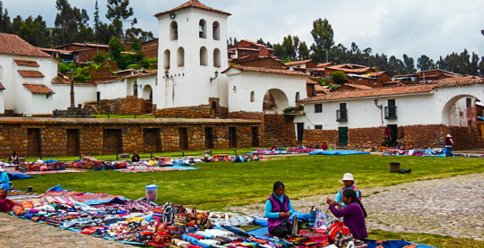
Chinchero known as the city of Arco Iris is located 28 km. to the northwest of the city of Cusco, on the 3160 msnm., flanked by the snowed ones of Salkantay, Verónica and Soray. The view from here is impressive. Chinchero belongs to the province of Urubamba, department of Cusco
Chinchero, the most typical population of the Sacred Valley of the Incas, is a distinctly Inca city that the conquistadores wanted to "civilize" to implant their culture, but never fully achieved it. Its inhabitants inhabit almost intact Inca buildings, in the same place where their distant ancestors lived and formed the largest and most prosperous civilization in America.
In the Archeological Site of Chinchero, its platforms are initially called, which allows us to understand that it was a center of agricultural production in the Inca period, a warehouse was also built and the whole complex was equipped with a very efficient irrigation system. The story goes that with the arrival of the Spaniards, Chinchero was burned down in 1536 by Manco Inca, in his flight to Vilcabamba, with the aim of leaving nothing to the Spaniards.
On the Palace of Tupac Yupanqui the Spaniards raised the Church of Our Lady of Montserrat in 1607, with the purpose of representing their submission in a symbolic way. Its main altar carved in gold leaf and baroque style is dedicated to the Virgin of the Nativity. Its walls are decorated with works by Diego Quispe Tito, the highest representative of the Cuzco school. There are also works by Francisco Chihuantito.
In Chinchero the past persists stubbornly, as if the spirit of a millenarian culture clung to this place, refusing to disappear. The native settlers, dressed in colorful traditional costumes, come down from their communities on Sundays and gather in the main square to exchange their products. Seeing all this group of people with deep cultural roots, oblivious to any sign of modernity, is a spectacle.
In the busy and colorful Sunday fair of chinchero you can find objects for domestic use, some truly old like the famous chinchero textiles. In this town, with united communities, it has been possible to preserve a living, immaterial heritage of extraordinary value, which is expressed both in textiles and in agricultural practices and in a network of family and community relations. In the workshops of the associations of artisans the whole process of the fabric is exposed daily, from the washing of the wool, to the final product, you learn from the techniques of spinning, dyeing and weaving.
From Chinchero you can access the beautiful Laguna de Huaypo and the town of Piuray. Chinchero is also recognized as a town of talented textile artisans.